Leave Your Message
0%

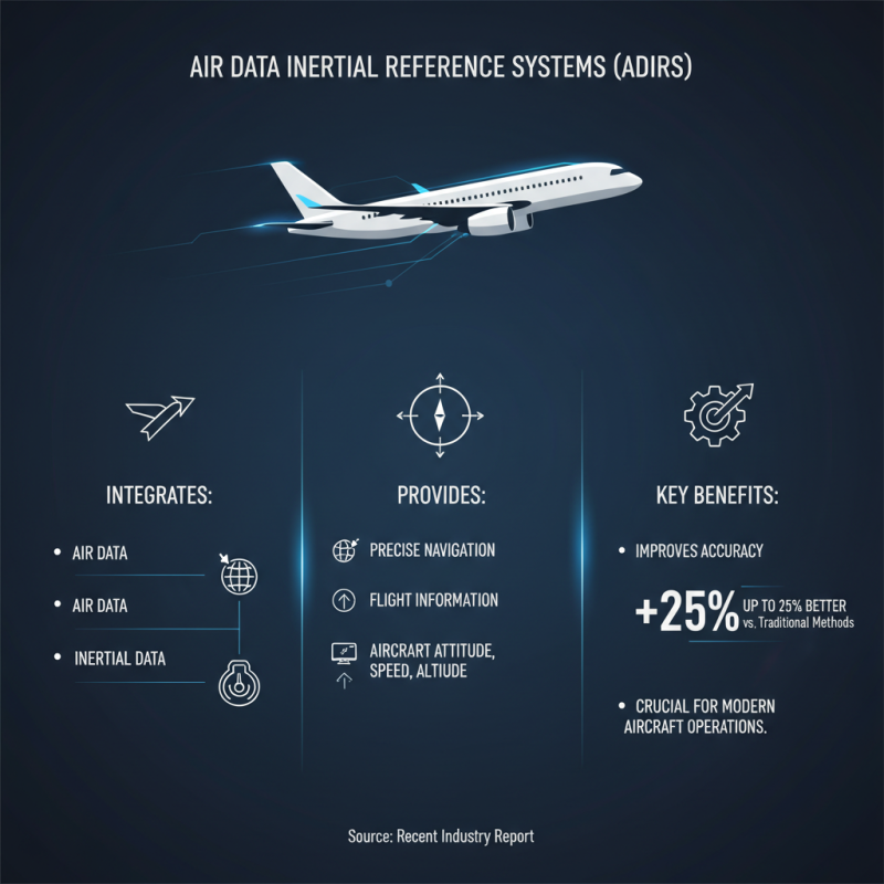
The Air Data Inertial Reference System (ADIRS) plays a crucial role in modern aviation. It combines air data and inertial information to enhance navigational accuracy. This system helps pilots understand the aircraft's position and movement in real time.

Understanding the ADIRS is vital for safe and efficient aircraft operation. It provides essential data, like altitude, speed, and direction. This information is often used in conjunction with other flight systems and avionics, ensuring a comprehensive flight experience. Pilots depend on the reliability of the ADIRS, but it is not infallible.

While advancements have improved the ADIRS, challenges remain. Sensors can malfunction or experience calibration issues. Thus, regular maintenance is crucial. Pilots must remain vigilant, as reliance on automated systems can sometimes lead to oversight. Awareness of the system's limitations fosters a more robust understanding of flight safety.

What is Air Data Inertial Reference System and How Does It Work?

What is an Air Data Inertial Reference System?

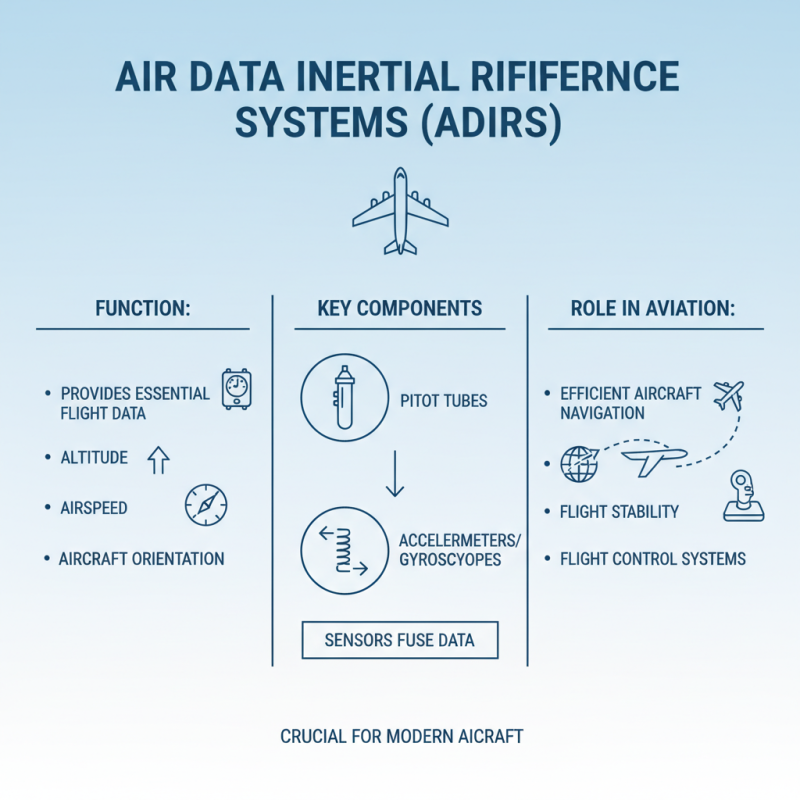
An Air Data Inertial Reference System (ADIRS) plays a crucial role in modern aviation. It combines various sensors to determine an aircraft's position, speed, and altitude. This system integrates data from airspeed sensors, altimeters, and inertial reference units. Together, they create a reliable flight path for pilots.

The key components of ADIRS include accelerometers and gyroscopes. Accelerometers measure changes in velocity. Gyroscopes help track orientation and rotation. Together, they provide a three-dimensional view of the aircraft's movement. However, it is important to note that errors can occur. For example, sensor drift may lead to inaccuracies over time.

ADIRS enables flights to operate smoothly, even in challenging conditions. But reliance on this technology can create blind spots. If the system fails or provides incorrect data, pilots must quickly adapt. Understanding the limitations of ADIRS is essential for ensuring safety in the skies.

Key Components of Air Data Inertial Reference Systems

Air Data Inertial Reference Systems (ADIRS) are crucial for aircraft navigation. They provide essential data about the aircraft's position, speed, and altitude. Key components of these systems include various sensors, avionics, and processing units. Each part contributes to the overall functionality, but they must work together seamlessly.

Pressure sensors measure dynamic and static pressure. This data is vital for calculating altitude and airspeed. Inertial measurement units (IMUs) track angular velocities and accelerations. They help determine the aircraft’s orientation in three-dimensional space. The integration of these sensors is complex. Errors can arise from sensor misalignment or drift, impacting flight safety.

Processing units interpret the data and present it to pilots and automation systems. They analyze inputs and ensure accurate readings. However, system failures can occur. Pilots must remain vigilant and be prepared for discrepancies. Understanding these components and their roles is essential for safe flying. It’s a delicate balance of technology and human oversight.

How Air Data Inertial Reference Systems Measure Flight Parameters

What is Air Data Inertial Reference System and How Does It Work?

Air Data Inertial Reference Systems play a crucial role in aviation. These systems provide essential data like altitude, speed, and orientation. They combine data from sensors, including pitot tubes and accelerometers. This collective information helps in navigating the aircraft efficiently.

To measure flight parameters, the system continuously assesses pressure changes as the aircraft moves. For instance, a pitot tube measures airspeed by comparing static and dynamic pressures. This pressure data is vital for maintaining safe flight conditions. The accelerometers track the aircraft's position and movement, providing real-time data on acceleration forces.

Despite their importance, these systems can encounter issues. Environmental changes can affect sensor accuracy. For example, rapid altitude changes might lead to errors in data interpretation. The Air Data Reference System relies on constant calibration to function optimally. Operators must regularly check these systems to ensure reliable readings and prevent flight complications.

The Role of Sensors in Air Data Inertial Reference Systems

Sensors play a crucial role in an Air Data Inertial Reference System (ADIRS). They collect vital information for accurate navigation. These sensors measure parameters like altitude, airspeed, and attitude. Their precision is essential for flight safety and performance.

Pressure sensors are particularly important. They provide data on air pressure changes outside the aircraft. This information helps calculate altitude. However, not all sensors work perfectly. Some may give inaccurate readings due to environmental factors. This can lead to significant flight issues.

Another type of sensor is the inertial measurement unit (IMU). It tracks the aircraft’s movement by measuring acceleration and rotation. The data from the IMU helps in stabilizing the flight path. Yet, if the IMU is miscalibrated, the results can be misleading. Combining data from both pressure sensors and the IMU creates a reliable Air Data Reference Unit. This fusion of information aids pilots in making informed decisions. The effectiveness hinges on the accurate functioning of each sensor.

Applications of Air Data Inertial Reference Systems in Aviation

What is Air Data Inertial Reference System and How Does It Work?

Air Data Inertial Reference Systems (ADIRS) play a crucial role in aviation. They integrate air data and Inertial Data to provide precise navigation and flight information. These systems help monitor an aircraft's attitude, speed, and altitude. According to a recent industry report, ADIRS can improve accuracy by up to 25% compared to traditional methods. This precision is pivotal for modern aircraft operations.

Applications of ADIRS are diverse. They support autopilot systems, enhancing aircraft control during various flight phases. These systems offer essential data for takeoff, landing, and in-flight navigation. A study noted that around 80% of new commercial jets are now equipped with advanced ADIRS due to rising safety standards. However, issues can arise, such as data discrepancies. Pilots must always validate the information received.

Moreover, the integration of Inertial Data into ADIRS allows for better performance in adverse conditions. For example, during turbulence, these systems maintain stable readings, helping pilots adjust their strategies. Yet, it's critical to monitor these systems regularly. If they malfunction, the consequences can be severe. Operators should reflect on the reliability of their ADIRS to prevent mishaps in aviation.

Advantages and Limitations of Air Data Inertial Reference Systems

Air Data Inertial Reference Systems (ADIRS) play a crucial role in aviation. They provide essential data for navigation and control. However, these systems come with advantages and limitations worth noting.

One primary advantage is enhanced accuracy. ADIRS combines air data with Inertial Measurement Unit Data. This fusion offers precise altitude and speed readings. Pilots rely heavily on this information for safe maneuvering. Such data helps in reducing human errors during flight.

On the flip side, there are limitations. Calibration issues can arise, introducing potential errors. These must be corrected routinely to ensure accurate readings. Additionally, if the system loses power, reliability can be compromised. Pilots need backup systems to mitigate risks. This highlights the importance of dual systems in aviation design. As technology advances, the potential for improvement exists, but challenges remain. Continuous assessment is essential for optimizing performance.

Air Data Inertial Reference System Performance Overview

This chart illustrates the performance metrics of an Air Data Inertial Reference System across various dimensions such as accuracy, response time, weight, cost, and robustness. The metrics are presented as percentages to provide a clear comparison of the system's capabilities.

Future Trends in Air Data Inertial Reference System Technology

Future trends in Air Data Inertial Reference System (ADIRS) technology are shaping the landscape of aviation. As aircraft designs evolve, so too does the demand for more precise and reliable onboard systems. Advanced algorithms are being developed to enhance data accuracy. These improvements enable better flight control and navigation, making flying safer.

Tips: Always consider how technology impacts your safety. Stay informed about upgrades in systems like ADIRS.

Another trend is the integration of artificial intelligence. AI can analyze vast amounts of data in real-time. This capability may lead to faster adjustments during flight. However, reliance on AI also raises concerns. Can we trust machines to always make the right decisions?

Tips: Question the technology. Understand its benefits and limitations. Balancing innovation with human oversight is crucial.

FAQS

: What are the main features of the product?

: The product is lightweight and portable. It has a user-friendly interface. Battery life is also impressive.

How can I improve my experience with the product?

Regular updates can enhance functionality. Customizing settings may also help. Explore tutorials for tips and tricks.

What should I do if the product malfunctions?

Check the user manual for troubleshooting steps. Often, a reset can solve many issues. If problems persist, contact support.

Can I use the product outdoors?

Yes, it is designed for outdoor use. However, avoid extreme weather conditions. Protect it from heavy rain or snow.

What are common misconceptions about this product?

Some believe it is waterproof, but it’s not. Users also think it can replace all traditional methods, but that’s not true.

How can I maintain the product effectively?

Regular cleaning is essential. Store it in a dry, cool place. Check for software updates often; this improves performance.

Is the product suitable for beginners?

Yes, it’s user-friendly for beginners. However, some features may require a learning curve. Patience is key.

Can I share the product with others?

Sharing is possible, but some features are personal. Be mindful of privacy settings. Discuss usage guidelines with others.

What if I change my mind after purchase?

Most often, returns are allowed within a limited time. Check the return policy before purchasing. Some conditions apply.

Are there alternatives to this product?

Yes, several alternatives exist. Each has unique features. Researching options can help find a better fit for your needs.

Conclusion

The Air Data Inertial Reference System (ADIRS) is a critical technology in modern aviation, combining sensors to provide accurate flight data essential for navigating and controlling aircraft. Comprised of key components such as inertial sensors, airspeed indicators, and altitude sensors, ADIRS plays a vital role in measuring various flight parameters, including altitude, speed, and attitude. By leveraging advanced sensor technology, these systems ensure precise and reliable data, which is crucial for pilot decision-making and overall flight safety.

The applications of Air Data Inertial Reference Systems extend beyond navigation, impacting areas such as autopilot functions and flight management systems. While ADIRS offers numerous advantages, including enhanced accuracy and reduced dependency on external references, there are limitations such as susceptibility to sensor errors and calibration challenges. As technology evolves, future trends in ADIRS are likely to focus on improving integration with other aircraft systems and increasing resilience against environmental factors, ultimately enhancing the safety and efficiency of air travel.

Emily

Emily

Emily is a dedicated marketing professional at Poseidon, a pioneering company founded in 2013 that specializes in independent research, design, and production of cutting-edge technologies such as fiber optic gyroscopes (FOG), inertial navigation systems (INS), and advanced autonomous driving......
Previous How the Best Inertial Sensor System Fuels China's Manufacturing Growth Amidst US-China Tariff Challenges